A couple of Christmases ago, I was flipping through a book about historic Middleburg homes and the surrounding areas. One story explained how the rural town was given its name. Travelers from Washington D.C. heading toward Winchester, the final outpost before the “Wild West,” dubbed a midway point between the two areas — Middleburg. That same corridor, now known as Route 50, is a living example of how people moved through the northern Piedmont hundreds of years ago.
The beauty of the Route 50 corridor is not an accident. It has taken multi-generational involvement in local decision-making to plan for and preserve this historic east-west passage. PEC has played a part in that by working with communities and partner organizations to identify threats and opportunities that could impact the corridor’s scenic character and its function as a powerful economic engine for tourism revenue.
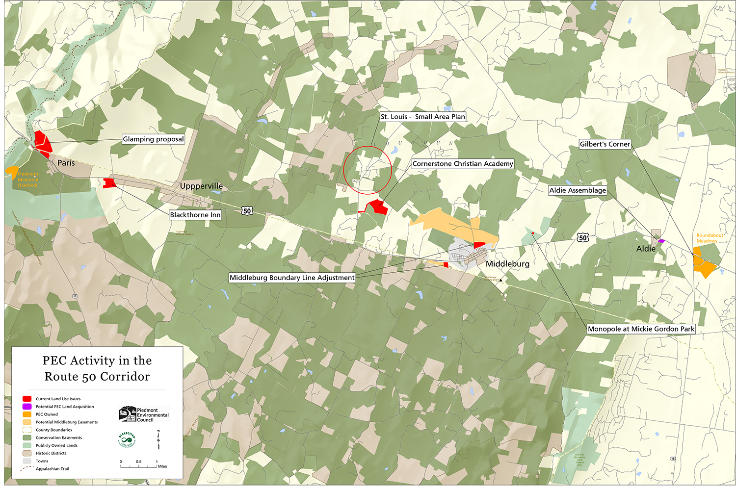
Earlier this summer, PEC hosted a community briefing at Buchanan Hall in Upperville to inform Clarke, Fauquier, and Loudoun residents about several land use proposals along Route 50 and to give them a chance to share their thoughts.
Mickie Gordon Memorial Park Cell Tower
A private development company has submitted plans for a telecommunications tower at Mickie Gordon Memorial Park,
between Middleburg and the historic village of Aldie. Several community organizations, including PEC, and many local residents believe that at the proposed location, the tower could negatively impact the visual character area. We also believe the location isn’t aligned with the County’s comprehensive plan. During a public hearing in July, public comments focused on a variety of unaddressed issues, such as tower height restrictions, cell coverage analysis and alternative locations.
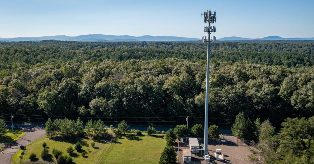
Based on those comments and the applicant’s refusal to extend the project review deadline, the Planning Commission denied the permit. Since then, the applicant has modified the proposal, lowering the tower height to 130 feet from the originally proposed 185 feet. As of press time, the Board of Supervisors was scheduled to review the project at a Sept. 14 public hearing. While the height reduction is a step in the right direction, with community concerns still outstanding, PEC thinks the Planning Commission should have more time to work through the details for the best outcome on this proposal.
Middleburg Boundary Line Adjustments
Two property owners along Middleburg’s boundary lines are considering submitting applications to have their lands incorporated into the town, with the intention of increasing the number of dwelling units per acre allowed on these land — their “housing density” — and developing accordingly.

The first is a 33-acre property west of town, where the property owner wants to build 60 clustered, leased units — some age-restricted and some subsidized — while leaving some of the property as open space. North of town, on a 212-acre property along Foxcroft Road, the other landowner wants to build 66 clustered for sale-units — some multifamily buildings, some single-family homes — leaving 190 acres as open space.
Currently, without a boundary line adjustment, each of these two properties can be developed, by-right, into a variety of uses allowed by Loudoun’s ordinances for agricultural zoned areas. The Foxcroft Road property, for example, could have a corporate retreat or 14 single-family detached homes spread across the entire 212 acres. Middleburg would have no control over the development type, design, or traffic flow, and any of the uses could be placed atop prime agricultural soils that ought to be preserved for farming.
St. Louis Village Plan
Loudoun’s Village Conservation Overlay District identifies 13 small villages and hamlets that contain unique scenic and historic characteristics that should be maintained and protected. But when the 2019 Comprehensive Plan was developed, an in-depth review of these historic villages and their land use needs was not part of that process. A recent development threat in St. Louis, one of the oldest African American villages in Loudoun County with a notoriously fragile water supply, has illuminated that omission and exposed zoning ordinances that put all of these historic communities at tremendous risk.
PEC, along with the Loudoun Historic Village Alliance, has been advocating that these villages should each have an updated vision for the future based on its current-day needs and challenges. Although Loudoun is in the midst of a zoning ordinance update, any zoning change for the villages must be preceded by comprehensive plan updates. Such updates must begin now so that appropriate zoning changes can soon follow.
Happily, our two-year effort to oppose the aforementioned development threat ended in a private conservation sale and the Board of Supervisors approved a community planning and zoning process for St. Louis to better manage the future
of the village. That process, expected to take 18 months, began with a kick-off community meeting in April, followed by a Board-appointed task force meeting in July. While not a task force member, PEC will continue to offer support throughout the process.
Other Projects
PEC is also paying close attention to a handful of other proposals, plans and issues along the Route 50 corridor. The Loudoun Board of Supervisors is considering an offer by PEC to purchase the Aldie Assemblage, a six-acre property that has been at risk of significant development that would have compromised the historic features of the site and character of the village. On the western end, we are hoping for a conservation solution for a property listed for sale that is adjacent to other conserved properties providing the brilliant views eastward from our Piedmont Memorial Overlook at Sky Meadows State Park.
In the area of Gilberts Corner, we are tracking the Tanager Subdivision proposal adjacent to the historic Mt. Zion Old School Baptist Church. Built in 1851, Mt. Zion was used as a Union field hospital during the Battle of Aldie and is listed on the National Register of Historic Places. Concerned about the significant negative impacts the proposed 31 single-family detached homes could have on the historic resources around Mt. Zion and the Old Carolina Road Trail, PEC is monitoring this proposal closely.
Nearby, PEC Farm and Land Manager Dana Melby is in the early stages of conceptualizing changes to the PEC-owned Gilberts Corner Market property. PEC intends to improve public ingress and egress at the farmers market, restore or rebuild the historic building at that site, and make way for an enhanced presence of local farmers and vendors.
I once heard someone say, “Gilbert’s Corner is the dividing line. Everything west of it is rural.” Maintaining the beauty and benefits of the rural area has been and remains the result of active civic involvement on topics like the proposals and issues we’ve described along Route 50 today. As I depart PEC to pursue another opportunity, community members with questions about these proposals can contact our field representatives Gem Bingol at [email protected] or Kevin Kask at [email protected].
This story appeared in The Piedmont Environmental Council’s member newsletter, The Piedmont View. If you’d like to become a PEC member or renew your membership, please visit pecva.org/join.